It’s winter in Ohio and I decide to take advantage of some time off to see something other than winter in Ohio. Erin comes up from Texas for a few weeks. Everything from the apartment gets moved back into the van. And just like that, we’re off. Unstated goals: find some sunshine, sit in the sand, spend our nights in a tent, our days in the open air… Paddle, run, hike, bike, and watch a few sunsets. To face west from the east.
Congaree National Park, South Carolina
We have never heard of Congaree until a few hours before we arrive. The first day’s strategy consists of leaving Athens and driving until we don’t want to drive anymore. Potential itineraries begin to take form on the road. Place names and possibilities begin to seem tangible only after a certain radius has been passed. Once forward motion seems sustained. Repeated map checks and sporadic internet searches become the passenger’s primary responsibility.
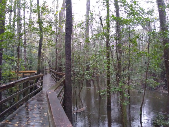
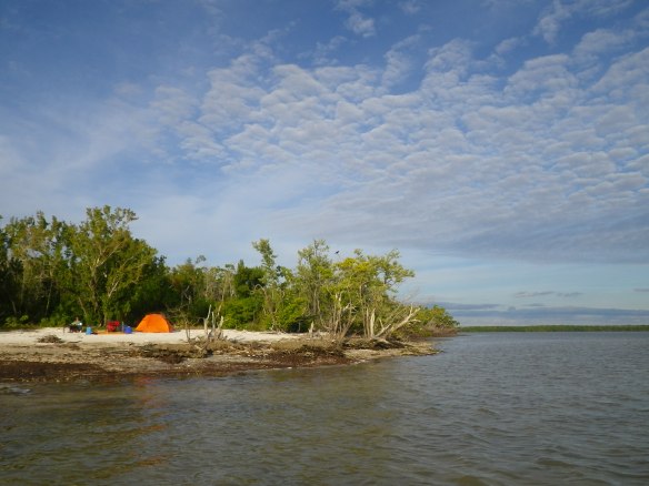
Snow flurries in the mountains of West Virginia. Creeping traffic and rain in Charlotte, NC. Darkness as we turn onto backroads in South Carolina. We make a quick stop at a convenience store/bait shop along an empty highway in the Deep South, and find that we are a world away from where we started that morning. The campground at the park is vacant, and also completely saturated. The entire park, in fact, is mostly flooded to some degree, something that apparently happens several times a year. At one point it was actually called Congaree National Swamp.
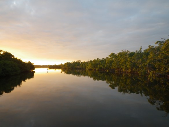
In the morning we cook breakfast early and make an effort to see some of that swamp. When it’s not flooded, wilderness float trips on Cedar Creek and the Congaree River are possible. A trail system also exists. With most of the ground covered in water, however, options are mainly limited a couple miles of elevated boardwalk, which makes for an engaging experience that morning as we stroll along it in a light rain. This type of ecosystem is a novelty for both of us, and I find myself imagining how much diversity exists in such a primal place, so seemingly inhospitable to our species, but entirely conducive to life all the same. It’s easy to envision dinosaurs wading through the trees.
Weeks later, on the way back to Ohio, we spend another night and most of a day at Congaree, which remains flooded. We make an attempt to paddle Cedar Creek, even going so far as to bike the shuttle, leaving the van at the take-out miles from where we put the canoe in. For the first bit a steady current carries us along, though we have to portage around or over a few fallen trees. Soon enough, however, the creek becomes nearly indistinguishable as we float further into flooded stands of cypress, forcing us to make the decision to either turn around or risk spending untold hours (perhaps days) trying to guess our way through. We make the sensible decision, a rarity at times, and find our way back to the put in.
Merritt Island National Wildlife Refuge
Upon leaving Congaree that first morning, we continue to head south, crossing the Georgia state line around lunchtime. We decided to spend the afternoon riding bikes around the historic district of Savannah, and stop near Forsythe Park to rent a second bike. The bike shop proprietor provides us with a map of the city and suggests a route, which we follow from park to fountain to park to fountain to the waterfront and back. It’s warm and sunny with a light breeze, a perfect spring day in mid-December. We see for the first time massive live oaks covered in Spanish moss which will become a familiar backdrop later in the trip. The light filtering through fern-covered branches and draped moss creates a calming, otherworldly environment.
That night we make it into Florida, and find a spot to sleep near the coast. Before turning in we walk a couple miles along the beach, illuminated by the waxing moon. In the morning, we drive for a while before pulling over to make breakfast with a view of the sun rising out of the Atlantic. Afterwards, we continue to head south in a less than direct manner, cutting back and forth from coastal highway to freeway in search of a good place for a run. Like Congaree, however, the trails at the state parks we stop at are also flooded, leading to a couple of false starts and frustration. Eventually, we fortuitously find our way to Merritt NWR, and an awesome introduction to wild Florida.
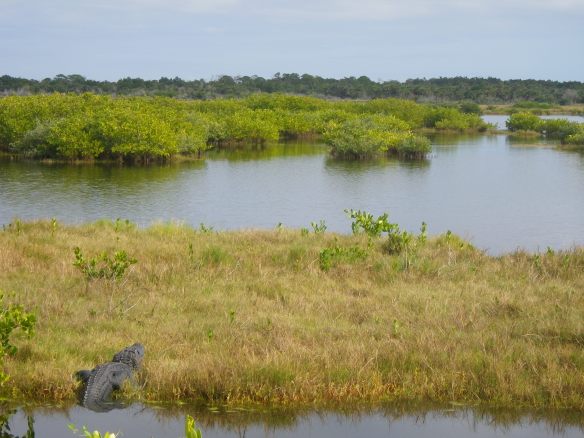
Upon entering the refuge, we make a stop at the visitor’s center for information on trails and the potential of seeing bioluminescence in the bays (turns out Mosquito Lagoon in the refuge is one of the few spots in the world to do so, but mainly in the summer months). Before leaving, I decide to take a quick stroll around the building on the interpretive boardwalk out back, which passes through a small patch of wetlands. On my way from the parking lot to the path, I see what surely must be a lawn statue of a small alligator strategically placed just off the back deck of the building. After studying it for a bit, I realize that it’s an entirely real alligator, about 3’ long. A few minutes later, I see another one, much larger, across the pond. I suppose I hoped to see a gator or two at some point in the trip, but never expected them to be as prevalent as they are in reality. And these two only serve as a prelude for what happens soon after.
From the visitor’s center we head over to Black Point Wildlife Drive, a seven mile one-way dirt road that traverses through wetlands alongside the Indian River. I spot a wild hog grubbing around on the banks of a pond, and then marvel at the avian diversity in all directions. Hooded mergansers, tri-colored herons, little blue herons, green herons, great egrets, great blue herons, osprey, roseate spoonbills, and on and on. There are many species I don’t recognize at all, and others I can only guess at. And then another alligator, like the first one, so dark black and still that it looks fake. Halfway along the drive we turn off to the Cruickshank Trail, a five-mile birding loop along raised earthen dikes through the marshes. We plan to run the loop, following it counterclockwise along the route. Things are nice and dry, with perfect conditions for running. Sunshine and light wind. It’s easy cruising with scenery and wildlife in every direction. About four miles into the run I’m leading the way. When Erin and I run together, we’ll usually switch out every ten-minutes or so, so I decide to let her pass once we get to the big black sand pile a couple hundred feet down the trail. A hundred and fifty more feet and I realize that my marker’s not a pile of sand, but an eight-foot gator, its body stretched almost all the way across the path, reed-lined ponds on either side.
We have no idea what to do. I’m familiar with bear protocol, and moose evasion, and what action to take in the unlikely event of a mountain lion attack, but neither of us has ever read anything about trying to sneak around a sunning alligator. I’ve seen videos of people interacting with gators, and don’t remember them being particularly aggressive, but I’m also thinking about how embarrassing it would be to get chomped my first day in Florida. Erin remains a sensible distance away while I approach the gator in order to gauge its reaction. No reaction. I get closer. Now there is a reaction, but from Erin and not the alligator, which is not moving at all. I try to find something to toss at the gator to see if it will kindly slide forward and into the water, but there is nothing around to throw. I get a little closer. Still nothing. Finally, I back up to stop the increasingly annoying reaction from the opposite direction. Erin and I discuss what we should do. The choices are: wait, which seems like it could take a long time; turn around, which means backtracking four miles instead of running just one more to the parking lot; or run past the alligator and hope for the best. Erin says I should go first, promising to follow if I am successful.
Again, I’ve seen videos of alligators, that’s about it. I’m know they can move much faster than I would like to witness from this distance, but think I can probably kick it into high-gear if this thing starts to shift position. I take a couple of deep breaths, and go for it. There is about a foot of space between the tip of its tail and the steep decline of the bank. I make it to the other side, and the gator doesn’t move at all. Now I’m on one side of it, about ten feet away, and Erin is on the other side of it, about 50’ away. And now that I’m not between her and the animal, she seems to be reconsidering her commitment to following me. I’m looking directly at the gator now, right at its matte-black eyeball (we later read not to ever look a gator in the eye…) which looks almost hollow in its prehistoric head. “I think it might be dead,” I say. On cue, and looking like an animatronic version of itself, the alligator very slowly raises its snout and crooks its head towards me ever so slightly. Erin starts to sprint. Just a she gets to the tail, which she later says she didn’t realize was so long that she almost had to jump over it, her eyes get huge, her arms pump furiously, and she kicks into warp speed, not stopping until she’s long past where I’m standing. As she runs past, the gator does a quick startled thrust upwards as well (which is why I think her eyes get big) and stays in this push-up position as we quickly move on down the trail.
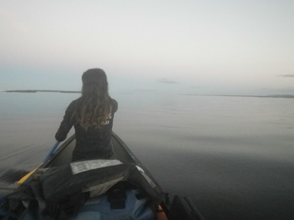
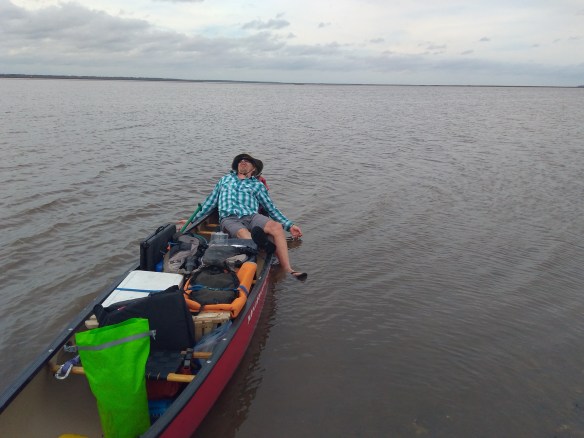
After that excitement, we drive the rest of the wildlife loop and head over to the Haulover Canal where we hope to see a few manatees. We take the canoe off the rack and paddle from the river side to the lagoon side, where they are reported to hang out. They’re not around, however, so we continue into the lagoon for a ways. Soon enough, we hear the forced expelling of air, and sit and watch for a while as a pod of dolphins hunt for fish only feet from the canoe. An inspiring first day in Florida.
10,000 Islands, Everglades National Park, Florida
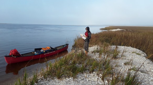
After around 1000 miles of driving, an exciting first day in Florida, and a few mini-adventures, we’re eager to get off the road, pack our gear into the canoe, and head into some wilderness. The spontaneous day-to-day road trip traveling style can be fun, but exploration feels more authentic when it’s human powered. The longer one can go without hearing an engine, the better. As such, we decide to point it parkward that third morning, hoping to make it into the Everglades region by early afternoon with the intention of starting a week-long paddling trip the following morning. And so it goes. A quick visit with the rangers and a map of the park allows us to come up with an itinerary and the required permit. We spend the night in Big Cypress National Preserve, organize our gear, and return to the ranger station the next morning for an early launch.
After unloading the boat and equipment, I head off to find a navigational chart for the area while Erin finalizes the canoe loading. At the local bait shop, I purchase the map and the woman there asks me what I’m up to for the day. When she hears that we’re going out for a week, she shows significant concern. Around that time one of her fishing guides comes in, and when she tells him what’s happening, he begins to describe an upcoming storm and his predictions for its outcome. While not a hurricane, the scene he offers sounds almost apocryphal in his depiction, with violent winds and fluctuating tides which will completely wash over most of the small islands we’re planning to camp on. Generally, I don’t pay a lot of attention to the weather or listen to second-hand forecasts, knowing that I’m simply going to deal whatever happens as it comes. This time, however, it seems serendipitous to have heard about the upcoming tempest, and prudent to at least consider what I’m hearing, as this individual appears to have a lot of experience with the area and effects of local storms. I thank them both, and head back to the put-in where I consult once again with the rangers. The one that helped us put together our plan earlier acts downright sheepish, saying that he has indeed heard of the impending squall, but forgot about it the day before. As such, we end up modifying our original itinerary somewhat, and it ends up being an incredibly good thing that we do, as two days later everything comes to pass as predicted.
Everglades National Park, which encompasses most of the southern tip of the Florida peninsula, offers visitors several different sections to explore. As most of the park consists of near impenetrable mangrove habitat, and the glades themselves, shallow sawgrass-covered wetlands, one of the best ways to see the park is by boat. And from a boat, the more accessible areas of the park are found in the keys, or small islands, which lie along the edge of immense swaths of wetlands, swamps, and sloughs. Boaters can gain access to portions of the inner ecosystems, but the general landscape is entirely unlike what I have always pictured when imagining canoeing in the Everglades. Over the course of eight days, we manage to find a few small creeks and passageways into the mangroves (as I’d always visualized), but spend most of our time paddling on open water between the keys, and across the large bays which separate the inner islands of mangroves. Our original course had us traveling inland first, as I guessed there would be more bugs there than out on the keys, but the switch has us paddling out to a couple of islands first, then looping back in for the storm, and finally paddling back out to another section of keys for the final few days.
In spite of the last minute plan adjustments, we push off relatively early in the morning, heading south and into the rapidly warming sunshine. Navigating through the keys provides a new challenge, as the landscape offers little in the way of recognizable features or landmarks. It’s simply open water and islands of green treetops and brown trunks all the way around. Everything is either sea level, or treetop level, and the shorelines offer nothing in the way of distinguishing characteristics to gauge the shape of each island of mangroves as we pass. Erin paddles and steers in the stern, while I sit in the front, alternating between paddling and trying to intuit the map. A compass mounted to the bow helps in deciding which direction to point.
The new plan has us paddling 13 miles out to Pavilion Key, which will be one of the longer days of the trip. This may not sound like a difficult distance to achieve in a day, and with ideal conditions it’s certainly not, but given the added factors of tides, winds, and waves, things can get interesting quickly, especially in an open canoe paddling across open water (by this I mean we often find ourselves further than a mile from the closest shore). After a couple of hours of paddling that morning, we end up arriving at the outer edge of the keys with the Gulf of Mexico in full view. Approaching the first sandy beach we’ve seen all day, we notice a woman sitting in a lawn chair watching her husband fish from his motorboat a short distance away. Not wishing to disturb her solitude, we decide to paddle around the island to look for a landing spot on the other side in order to eat lunch. In the end, however, the other side has nothing but waves (and almost us) crashing into reef, so we end up making a loop and pull up next to her just as her husband comes in for extraction. They live in the local area, so we chat for a few minutes before they leave and find out that we’re one key off of where we thought, which provides a good sense of scale regarding the map with relation to the landscape we’re traveling through.
After a quick bite in welcome shade, we direct the canoe south towards our first bigger crossing of the trip. As we start the traverse, the wind kicks up, and small waves begin moving laterally across our path and into the side of the boat, occasionally nearing the top of the gunwales. Nothing too extreme, but stimulating conditions to be sure. While the navigational charts include depth, knowing that the choppy waters around you are only around 6’ deep doesn’t do much to assuage the imagination once we find ourselves miles from shore for the first time. Capsizing in this situation probably wouldn’t prove deadly, but it would be mean serious catastrophe and a difficult self-rescue. Mental reprieve comes in the form of a heavy breathing manatee which surfaces off the bow before disappearing. After a couple more hours of focused paddling, we arrive at our destination for the evening, an extended sand spit forming the capacious beach of Pavilion Key.
The way the NPS manages these areas is through the issuance of camping/trip permits only given out the day of or the day before your trip. You show up with a couple of itinerary ideas, and go from there depending on availability. No matter what, you’ll most likely end up with a trip similar to your desired plan, though might have to make a few slight adjustments regarding specific destinations. The longer you plan on staying out, the more flexibility you’ll have in creating your route. I’m sure a lot of people don’t like this first-come first-serve system, but personally I love it, and know how impossible it can be to be spontaneous in the era of internet and required reservations. I get why a lot of the parks run this way – avoiding overcrowding, maximizing revenue, etc. – but in my mind it completely kills the sense of adventure and punishes the free-spirit.
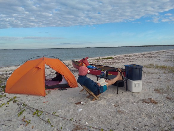
The keys themselves prove remarkable, each separate island resembling a small piece of Caribbean paradise. Sandy beaches, the occasional palm tree, and views for miles across open expanses of sea. Within the permit system, each island has a maximum occupancy, both group and individual. Rabbit Key, for example, a smaller key, allows two groups and a total of eight people. Camping on most of the keys is along a spacious beach, though some of the islands have smaller, more private sites scattered around the coastline. The only development on the islands comes in the form of boat serviceable port-a-lets meant to be shared by everyone on the island (all the ones I visited were remarkably clean – great job NPS crew!). In the 10,000 Islands region there are seven or eight keys designated for camping, along with several inland sites. For conservation purposes, stopping on other islands is not permitted.
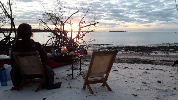
Pavilion, where we stay the first night, proves to be one of the larger keys in the system. We end up sharing the space with one other group, a contingent of young sea kayakers who decide to set up camp about 100’ from our tent, even though the beach is over a half-mile long. They’re quiet and respectful kids, however, and barely noticeable as our first sunset viewed from the keys lights up the open sky around us. (The keys prove to be the perfect East Coast sunset spot, as most all of the beaches have sections oriented directly towards the Southwest.) In the morning we cook a big breakfast of eggs and potatoes, and spend an hour strolling the beach before departing.
From Pavilion, it’s a 4.5 mile crossing to the next night’s stay on Mormon Key, though we opt for a more circuitous route along the coastline in order to occupy the day with activity. This proves to be a wise decision, as the wind picks up rapidly as soon as we start paddling. Unlike the previous day, this time it comes as a headwind from the southeast, kicking up waves high enough to occasionally splash over the bow of the boat. Paddling directly into the waves and wind, however, proves to be much easier than when they were coming from the side, and though it’s a grind, we end up falling into a rhythm which moves us steadily forward. A couple hours into our paddle the wind is strong enough that we elect to take a slightly longer inland route instead of continuing across the open Gulf, a plan that works out well as we navigate our way through sheltered bays before eventually coming back out just in time to make the short crossing over to Mormon Key.
Once across, we paddle around most of the island, finding a small beach on the southern tip which makes for one of my favorite campsites of the trip. It’s like having a tropical paradise all to ourselves, the wind a slight breeze from this vantage and the sun warm enough to allow for a mid-afternoon swim. We spend most of the afternoon lazing around in the sun. In the evening we gather driftwood for a fire, which you’re allowed to build below the high-tide line at beach campsites, and begin preparing dinner as we again watch the sun set directly in front of us. A truly memorable day and an unforgettable campsite, though soon for reasons other than its sheer beauty and solitude.
A word about insects. Like most people, I don’t enjoy being munched on by bugs, losing blood to mosquitoes, tweezering off ticks, etc. I’m okay with foul weather, willing to accept the risk of recreating among predator species, comfortable with discomfort, and fine with some physical and emotional suffering on vacation from time to time, but I’m not really okay with insects in copious quantities. “Lots of bugs” is perhaps the one thing someone can tell me about an area that will significantly decrease my desire to go there. Which is probably why I haven’t been to the Everglades until now, the place name itself immediately conjuring images of face nets and bug spray and endless swatting and shooing and the scratching of skin hives. Park literature doesn’t deny the existence of insects, rather it does all it can to apprise potential visitors to the reality of a hostile ecosystem. But words will always fail to describe what it’s like to operate amidst a relentless attack of determined swarms of infinitesimal winged parasites. I’m sure you can guess where this is going.
For the most part, bugs weren’t really a major issue on this trip. Reportedly, insect activity significantly decreases in the winter months in all the swampy coastal areas we visited. Many visitor’s centers and park entrances and businesses in these regions display some humorous homemade variety of a “mosquito meter,” generally a hand-painted wooden graph with an adjustable pointer ranging from something like “All Clear” to the extremes of “Combat Zone” or “Blood Donor.” Throughout our travels their arrows are generally resting around what would be a two on a scale of 1-6 or so. On the keys, things are generally meant to be better than inland, mostly due to the reliable island breezes blowing in off the water. And that is the case, most of the time. On this particular night, however, just as we begin to tuck in to our evening meal, an almost imperceptible change occurs. The wind, which we’d experienced since leaving the beach the day before, suddenly stops. And then another, immediately obvious change occurs as we diners suddenly become dinner. There are mosquitoes, to be sure, but also bloodthirsty hordes of no-see-ums, nearly invisible (as the name suggests) gnat like creatures with a vicious bite and a voracious appetite. Things get miserable. Erin barely finishes her food before retreating to the tent. I try to pretend things aren’t so bad as I douse myself with repellent and break out a face net that I’ve owned and never used for years now. I light the fire and try to hang out for a while, but the breeze fails to return, and the net proves ineffectual at providing full protection. The bugs still penetrate somehow, finding every exposed piece of skin imaginable. And then there’s the hum. The droning trill of biomass. The only course of action remains to dive into the tent, zip it up tight, and assist Erin with her in-progress killing spree.
In the morning, things haven’t improved much, so we swiftly pack our bags and get out of paradise with a quickness. Thankfully, those 12 hours or so will be the only time on the entire trip where the bugs prove downright intolerable. The rest of the time, they truly aren’t that bad, and cooler evening temps and breezes allow us to wear sufficient clothing to cover most of our bodies, while a bit of bug spray (from a bottle I’ve had about as long as that face net, such is my aversion to insect prone areas) is enough to keep the bites to an acceptable level. The lull in the wind turns out to be the proverbial calm before the predicted storm, as this is the first day of the bad weather I’d heard about in town. Once on the water a gale begins to build, though as we’re now headed inland, and traveling with the morning tide, the wind pushes us along for 8 miles as we head up the tidal Chatham River and into Sweetwater Bay, where we plan on waiting out the storm over the next couple of days.
On the way there, we stop off at an old ruin/habitation called Watson’s Place, which also serves as a campsite. In addition to the island camps, there are two other types of campsites in the area, ground sites and “chickees.” Having avoided signing up to stay at a ground site, we stop to check one out just to see what fun we might have missed out on. Watson’s Place is indeed not somewhere I would personally care to spend any significant amount of time. Ground sites are small swaths of cleared land along the otherwise heavily vegetated river banks. They are described as having the potential to be more buggy than the other two options, and also offer additional opportunities for undesirable experiences in that they’re commonly visited by alligators and snakes, a fact reiterated through semiotics on a sign at the dock which displays illustrations of a man, an alligator, and a snake with symbolic representation prohibiting the molesting of the animals by the person (though not of the person by the animals). Indeed, the place looks buggy, snakey, and gatory.
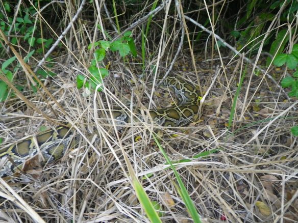
It should come as no surprise then, that as I’m flip-flopping around the site I almost step on a very large python near the corner of the clearing. It does come as a surprise, however, as even though I’ve read about the invasive pythons previous to this visit, I certainly never expected to place my foot inches from the engorged body of a six-foot long serpent with a mid-body girth of a human thigh. After the initial shock of discovery, followed by recovery and the realization that the snake doesn’t seem to be particularly lively, I take the opportunity to inspect it from a short distance. Pythons are not native to the Everglades. They exist as a product of irresponsible human actions and their own adaptability. It’s an intriguing story which I won’t get into here as the details are readily available elsewhere if you are curious. In short, the species has proven to be incredibly destructive to the ecology of the Everglades, taking a huge toll on the resident fauna and vying with alligators as the region’s top predator species. State-wide programs exist to eliminate the snakes, but this has proven incredibly difficult to achieve. Knowing all of this, I still have no idea what I should do upon seeing this specimen sitting in the grass in front of me. It’s huge, and even if I wanted to “euthanize” the snake, as I’m guessing would be optimal, I don’t have permission to do so, or the slightest idea as to how I would go about doing it. In the end I take a couple of photos with plans to report its location to the rangers at the end of the trip. And then we leave. Happily.
An hour later we are blown across Last Huston Bay and up past Sweetwater Bay to the “chickee” where we’ll spend the next two nights. This third type of site is named after dwellings once utilized by indigenous Seminoles. Their contemporary construction consists of metal-roofed wood and composite structures anchored by concrete pylons well away from shoreline. When we round the corner, we’re surprised by how exposed this site looks given the current weather conditions. It’s two platforms joined by a small deck and a port-a-let, sitting about three feet above the water in the middle of a small bay. What would generally be a unique setting looks a tad unprotected given the steadily increasing winds. But hey, definitely no bugs.
With the force of the wind now generating bigger and bigger waves, pulling up to the structure and exiting the boat proves to be a challenge in itself. Once we’ve tied off, we’re unsure as to what we should do next, as getting anything out of the canoe seems a precarious option with violent gusts whipping across the tiny unshielded platform. After a few minutes of assessing the situation, we decide to move a few heavy boxes out of the boat, and attempt to build some sort of windbreak by utilizing the roof supports. The only item we have with us that might be suitable to the purpose is a mesh sand mat that we miraculously threw into the boat as a last minute impulse. Always a novelty item before, it proves to be a crucial component over the next couple of days as it works surprisingly well once we get it secure, which is no small feat. It doesn’t fully block the wind, as nothing short of solid walls could do, but it allows us a bit of reprieve. From here we arrange our gear boxes around the corners of the platform in order to create a place to hunker down for a while as we determine our next plan of action.


It’s kind of an intense place to be. We are definitely a long way from anywhere, and know that we’ll not see another person for quite some time. The platforms barely provide enough space for a pair of backpacking tents in ideal situations, and the wind makes this one seems very minuscule indeed. Each movement requires conscious action. Anything that blows off the sides, or even falls through the cracks in the decking, will certainly be gone for good. Even if it were to float, retrieving something by boat seems highly unlikely and perhaps physically impossible given the conditions. The wind rips across the platform, and the water below courses past at significant speed. We’re sitting perhaps 50’ from the closest shore, though the shores here are not solid pieces of ground where one could huddle up and wait out a storm, they’re impossible structures of intertwined roots sheathed in razor sharp oyster shells. In an emergency one could probably survive on top of them for a couple of days, but it would be most unpleasant. The wind is now blowing hard enough that it doesn’t seem imprudent to assess the structural stability of the chickee itself, though it seems sturdy enough in spite of a few random creaks and strains. Still, worst case scenarios come to mind. We sit behind our boxes and snack on whatever happens to be on top of the food supply. For now, the rain hasn’t started, and it’s warm enough out that extra layers aren’t required. We’re also happy to be sitting where we are, miles from the Gulf, rather than stranded on one of the keys.
Eventually, the wind abates for a while. Slows down some at least. We cautiously manage to set up the tent, utilizing gear straps to secure the corners to the decking. After, we put everything but the food boxes into the tent to weigh it down. At that point, we ease in to the idea of waiting out the storm here, and consider our fortune in having heard about it in advance as we contemplate the route our original itinerary would have had us doing for the day, which would have been both dangerous and downright unmanageable in these conditions. The wind picks up again, and big clouds begin to build to our north. Impressive sheets of rain begin to rip across the bay in waves, though the roof provides just enough dry space to stand and watch for a little while. A powerful experience. We spend the rest of the afternoon reading and sleeping in the tent, listening to the world rage outside. Thinking we will most likely be going without supper, just before dusk everything stops. We get out and cook a quick dinner. The sky begins to darken, an alligator swims lazily by, unconcerned. The sky goes black. The wind starts again in earnest.
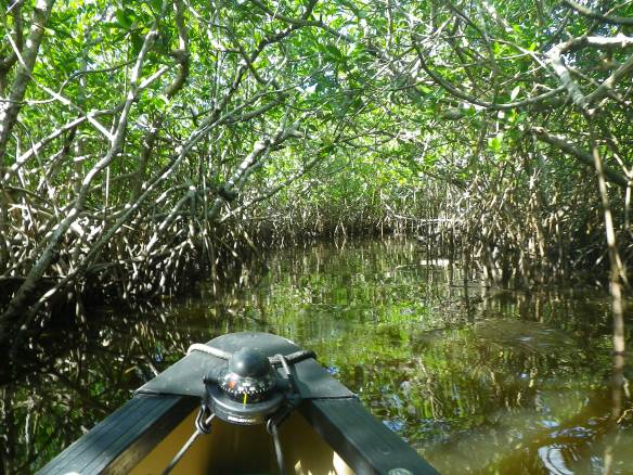
In the morning, a lull. We crawl out of the tent and make breakfast. The storm forecast calls for it to continue throughout this day as well, and we are scheduled to stay another night on the chickee. The idea of not loading up the canoe and trying to go somewhere specific is welcome, though the idea of spending the entire day cooped up on the platform not so much. As the wind doesn’t seem to be all that bad, and the clouds not all that ominous, we pack a lunch and paddle the empty canoe back out the direction we came from. The map offers several options, and we end up heading north on Deer Island Creek for a while, with easy paddling once we make the turn out of Sweetwater, the wind now behind us. The best part of the day occurs when we discover that the small squiggly black lines on the map, seemingly unnavigable as drawn, represent narrow passages through the mangroves. Turning into one of these outlets immediately gets us out of the wind, and onto a slender channel winding through heavy vegetation, coming out a half-mile later on another windswept bay. This is the type of paddling I always imagined doing in the Everglades, ducking under branches hanging across the creek and similar fun, and it’s enjoyable to be so immersed in such a foreign environment. After turning back around, we continue on the river with the optimistic idea to cross a much larger bay in order to check out the Alligator Alley channel a couple miles away. Not happening. Once we arrive at the confluence with the bay, we experience the maelstrom in progress as wind and waves thrash across the water. It’s difficult to turn the canoe around without being driven into the mangroves, or swamped by the spraying waves. We manage to do so, without event, and begin the arduous paddle back to the chickee, which first requires battling our way against the wind back to the mouth of the river we’d just sailed down. We pay for a laugh when, after a misjudged turn, we end up at a dead end we’d already seen earlier that day, both of us recognizing the spot at the same time. It requires significant effort to paddle back out the second time around. We finally arrive at the river mouth only to have to work even harder to make it across the small section of bay separating us from the Sweetwater, eddy hopping from one wind sheltered stand of trees to the next. Once on the Sweetwater, however, welcoming déjà vu awaits as the wind pushes us all the way back to the chickee, where it continues to blow for the rest of the night.
Around 5 a.m., all is calm. After many restful, then restless hours of lying in the tent, we’re ready to move. Getting out of the tent before first light proves much easier when the weather allows for flip-flops and shorts while drinking coffee at daybreak. As the trip progresses, we wake up earlier and earlier, often getting on the water as the sun begins to rise. Two things about winter expeditions: you need more days to explore due to the limited amount of daylight; and, when it gets dark at 5:30, you spend a lot of time in your tent no matter what the weather’s like.
We welcome movement this morning, knowing that we have many miles to go, and four major bays to cross on the way to the next chickee where we’ll be spending the night. We make a mile before the sun hits the horizon, and glide across the glossy surface of the first bay before the wind realizes what we’re up to. It catches on once we enter the second bay, but thankfully lacks the fervor of previous days. Slightly chilled by the breeze, we paddle 11 miles and get our tent strapped down to the chickee deck before lunch. The rest of the day we paddle around the area and explore a couple of the black squiggles on the map, getting in to one small overgrown creek nice and deep. We dodge, duck, push, and pull our way through heavy thicket for an hour before deciding to turn around, probably less than a mile from the entrance. Hundreds of tiny crabs on the tree roots provide additional entertainment, along with a chance couple of ibis.
When we arrive back to our platform, a group of four occupies the adjoining chickee, and tells us that they had originally planned to stay several nights, but no permits were issued once the park service realized the severity of the storm. We are again thankful to have been fortuitous enough to have made adjustments, and to have weathered it all alone on our little stand in the bay. That night I take the canoe out for a solo spin under the light of a full moon. The intensity of silvery glare drives me into the shadows. I float several miles in complete stillness, unanticipated in this tropical environment, the silence broken only by cautious paddle strokes.
Up early the next morning, we eat and pack with a quickness before bidding goodbye to our chickee mates. We paddle out with the receding tide, our destination the keys once again. On the way, I notice what could be an alternate route through the mangroves on the map, and having all day to paddle, we elect to go exploring. We weave our way slowly down a canal for a couple of hours, eventually floating into a maze of mudflats with the tide still on its way out. Ibis, roseate spoonbills, and a variety of herons inhabit the rich feeding grounds. We marvel at the scene, and somehow manage to scrape our way through the muddle and back onto the open water. A few miles later we watch a loggerhead turtle, or two, rise and disappear, rise and disappear.
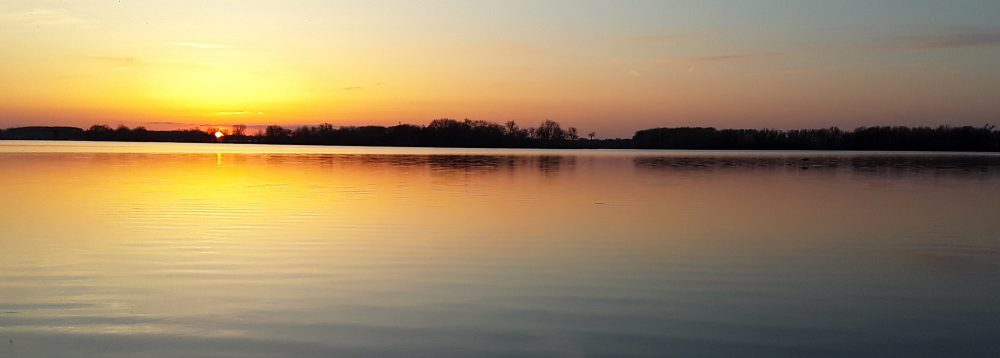
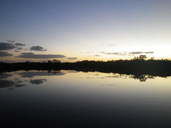
The next two nights we spend on the islands. Evidence of the recent storm abounds. The camping location at Jewel Key, normally several feet higher than the tides, is covered in detritus from waves washing completely over the island. I would probably be writing a much different story right now had we been out there as scheduled. From there we cross over to Tiger Key, stopping to admire flocks of great white pelicans standing together on white beaches along the way. Our last night in the area happens to be Christmas Eve, our camp a small private beach. We get in the canoe and paddle around as the sun sets, the sky to the east slowly shifting lavender, indigo, cobalt, even deeper blues without need of names.
Christmas breakfast: fat burritos and Florida grapefruit. Another sunrise. A tough paddle out against the biggest tide of the month and a steady offshore wind. Punished for our impatience and unwillingness to wait for the tides, we make nine or ten miles in around six hours. The last couple of miles necessitate traveling down the shoreline, our paddles constantly digging into inches of silty mud. Most unsatisfying, though laughable if not for the frustration of awkward and inefficient strokes. We arrive at the dock in good spirits all the same. It’s early afternoon, and downright hot out. A couple of spoonbills methodically shovel through the silt at the take-out. As we derig, a hurried Brit and his partner pull up with their kayaks. He asks about the situation with the rangers due to the shutdown. I have no idea what he’s talking about, and wish I still didn’t.
Peace River, Juniper Creek, and Silver Springs
We spend the next couple of days hanging out in the nearby Collier-Seminole State Park. The most memorable experience comes when we try to run the park’s six-mile “Adventure Trail,” apparently devastated by one hurricane or another in recent years, and end up on a 3-hour bushwhacking excursion through brush, briars, and sawgrass. Over a week later, deep crosshatched cuts on our legs remain as a reminder of the fun. We eventually decide to start driving north, constantly deliberating what we should do next. Almost all of the longer rivers we’d considered running are still seriously flooded, with no signs of falling water levels. Options for other paddling possibilities in the state are almost overwhelming in scope, though most would only be shorter trips, each requiring significant shuttling logistics for only 2-3 days on the water.
As such, we spend the next couple of days working our way from one seven-mile stretch of river to the next, still trying to figure out the best place to get back into some semblance of wilderness for another extended expedition. We waver between too many potential options, most of them only rough ideas encumbered by current water conditions. We paddle a short section of the Peace River, counting gators on the way down. We make our way up to the Ocala National Forest and end up at Juniper Springs, a campground next to a large freshwater spring, where we run on a section of the Florida Trail through a bizarre backdrop of funky flora, and follow up with a swim in the natural pool.


Our last day in Florida easily rivals the first. Wildlife encounters abound. We wake up in the dark in order to get an early start on Juniper Creek, a tiny trickle of clear cool water coming directly out of the spring itself, the put-in barely deep enough to float a canoe and not much wider. The current cruises along at a decent clip, carrying us into constant corners and through dense stands of jungle. We ride it for seven miles or so, the clear water allowing us to see everything below us, including a snapping turtle the size of a dutch oven slowly patrolling its way upstream. Schools of fish, a snake launching from its branch into the creek. We spot deer through the foliage, several alligators only a few feet from the boat.
The same afternoon we find our way to Silver Springs and another clear water stream emerging straight out of the earth, this one with much more volume than the first. We paddle a loop around the spring itself before moving down the river. There is everything here in abundance, birds, fish, gators, turtles… We have also come to see the monkeys, and a few miles down we do. Only here and the Florida Keys do primates live in the wild in the US, though they are non-indigenous and often a source of controversy. When we do spot them later that day, however, we’re not sure whether to look up or down, as several manatee emerge all around our canoe. They are only inches from our boat, often just beneath it, or underneath the floating aquatic plants beside it, nibbling at them from below. They slowly surface, breathe heavily, and dive again, their deeply scarred bodies baring signs of encounters with engine props. Near the confluence with the Ocklawaha, we’re still seeing new things – a six-inch baby gator sunning on a stump, a pair of purple gallinules. We get off the river late in the evening, and camp that night on the banks of the Ocklawaha River.
Cumberland Island National Seashore, Georgia
That night we make a decision to move on the next morning. To leave the state. The rivers we want to run, mainly the Suwanee and the Apalachicola, will not be accessible anytime soon due to water levels. It’s not that they’re particularly dangerous at flood stage, it’s just that they spill over their banks into the surrounding lowlands, convoluting routes and submerging camping locations. At least that’s my understanding of it based on what the people we’ve spoken to on the phone have told us, and evidence of such was apparent even on the Peace River. It’s time to move on to something different, and even though there seem to be a lot of amazing parts of Florida left to see, we would rather be in one general area on one focused trip than driving around each day only getting pieces of nature a little at a time.
Having not spent much time in the east, I had never heard of Cumberland Island until this past October when I began to ask around about potential wilderness opportunities in the southeast. The person who told me about the island had recently camped there for a week, and said that he would have stayed much longer given the opportunity. I made a mental note to check it out myself at some point, and even considered the possibility of a visit on the way down to Florida. A bit of research and a phone call to the park office made it seem like an awful lot of required planning and reservations would be required, however (see previous comments on spontaneous behavior in Everglades section…), which I was not excited about committing to.
All of the sudden, however, thanks to Day-Glo Donnie’s ego and his red-herring of a wall, an exceptional opportunity emerged.
Cumberland is a 17.5-mile long barrier island that sits a few miles off the coast of southeastern Georgia. The island has a rich history of occupation, including ownership by several wealthy families over the past few centuries. In the 1970s, the Carnegies, major landholders on the island, forged a relationship with the federal government which allowed for the creation of a national seashore that now encompasses most of the main island, though some property owners retain ownership and property rights for the remainder of their lifetime, meaning there are still a few people living on the island. The storyline goes that most of the landowners in this era did not want to see intensive development, as was happening in similar locations up the coast, destroy Cumberland, so they figured out a way to preserve it for future generations. Of course, there were a few private interests served as well, but overall the idea proves noble in implementation. Visitors may enjoy untrammeled, unpopulated beaches, and explore miles of uninhabited trails leading across the island through landscapes of saw palmettos and live oaks.
At least that’s how it seems while we’re there, the untrammeled unpopulated uninhabited part. Hardly a person to be seen as most visitors come over to the park via a regularly scheduled ferry which runs from St. Marys, Georgia several times a day, now suspended due to the government shutdown.
There is also the option, of course, of arriving at the island on your own boat, motorized or human powered, though even the shortest paddling distances require several miles of open water navigation. So during the shutdown it basically comes down to this: the park is open, but only equipped or fairly determined individuals have access to it (it’s possible to find a water taxi in St. Marys); camping reservations are nullified and unrequired; and no one knows when or if any of this is going to change. Talk about unanticipated circumstances and invitations for spontaneous journeys…
I will be honest and say that it is with mild trepidation that we depart from Crooked River State Park in Georgia and begin paddling the seven miles over to the island. The situation in general seems ideal in some ways, but creates anxiety as well. Thoughts of anarchy and lawlessness? I’m not sure what. I guess I should have more faith in the rest of humanity, but part of me hates to think of our public lands being advertised as unprotected. I’d like to think that most people value and respect what they stand for, and the places themselves, but I also know that not everyone operates with this mindset, especially if they think they can get the best of the government somehow. (Though within our current government, of course, there are people in charge of our public lands that want to do much worse than build an illegal campfire…) A mild unease sits with me the whole trip, though the few other paddlers/campers we meet seem to be there for the same reasons we are, to capitalize on an exclusive and otherwise negative situation solely for the positive aspects of the possibilities. For over a week, we have a whole national park, a whole island, almost to ourselves.

I won’t get in to the day to day. We leave the state park that afternoon without any idea as to what we’ll find or what we’ll do. We think maybe we’ll stay for a few days, and end up staying for nine. We only see one or two people a day, many of them locals and all extremely kind. They are happy that we’ve made it over, and all of them hope that we will enjoy the island. While we’re out running on the third day, a man on a four-wheeler with his basset hound riding in a basket stops to chat. His name is Thornton Morris, and we later find that he’s an attorney who helped to create the legislation to make the island a park. He invites us to stop by his house, where he presents us with a book he wrote filled with vignettes and personal memoirs from the island. It’s enjoyable to read it over the course of our days there. The few other visitors that we meet are also entertaining, each with their own mission.
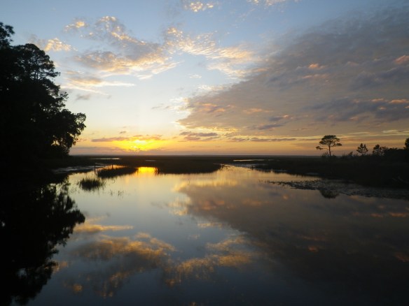
We spend the first few days running and hiking most of the trails on the north half of the island, making big loops consisting of several miles of trails combined with a few miles of beach travel. We stay several nights at the Brickhill Bluff site, including a peaceful New Year’s Eve. Our camp faces west to the mainland, and the sky lights up in oranges and reds each evening. Later, we embark on a difficult day of paddling to the south end. Strong tides and wind beat us down for the better part of the day as we cover perhaps 12 miles over the course of eight hours. There are a few days of paddling on this trip where I have to remind myself that if it was easy, or even fun, we wouldn’t be out there alone. That the suffering begets the rewards. Half-a-mile from the dock, dark clouds cut across the sky, drenching us as we continue to paddle, knowing that if we stop we’ll only get blown backwards for who knows how far.
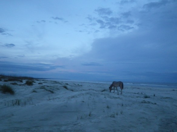
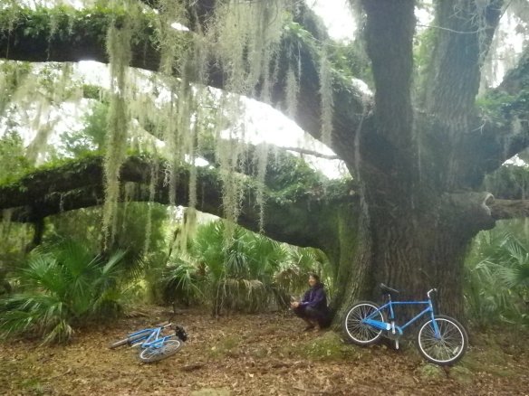
The next four nights we have the main Sea View camp almost completely to ourselves. A boat captain dropping off a couple of backpackers tells us that there were 120 people there the week before the shutdown, as it’s the most popular spot on the island. Erin harvests the grapefruit and oranges from the laden trees around our site. Each day we see several of the wild horses the island is famous for, along with the armadillos, hundreds of shorebirds, and the occasional deer or wild turkey. We walk and run miles along trails and beach without seeing another person. For a couple of days we borrow, with the unofficial off-the-record blessing of a ranger on a morning visit, beach cruisers from the ranger station and ride for miles around the southern part of the island. We wander around the ruins of the Dungeness mansion, evidence of the immense wealth and privilege of Cumberland’s recent history. Eventually, having checked out almost every part of the island, it is time to leave.
The last morning we get up while it’s still dark, hoping, for once, to ride the tide the right direction and also beat the wind. We eat oatmeal under the still bright stars, and drink our coffee as Mercury reveals itself against the coming dawn. We load the canoe from the dock, and take our first paddle stokes as the day breaks around us. Thankfully, we time everything just right.