I’d been hoping to visit Peru for some time now. Visions of big mountains and colorful costumes. Of llamas and pan flutes. Snowcapped peaks and stony ruins. All somewhat accurate, turns out, though most of the flute playing these days seems to happen more in vacationer filled restaurants than atop high mountain passes. The high mountains themselves, however, still abound, far exceeding anything my imagination could have fabricated. The ruins too. The glaciers. As for the bright customary garments, the alpacas and llamas, they seem to split the divide between touristy show and traditional existence. Easier to spot in the cities than in the hills, but still part of a viable lifecycle in remote rural areas which have changed very little over the course of centuries.
We only had a short couple of weeks to visit Peru, which wasn’t initially how I had envisioned seeing the country, but it turned out to be just about right in the end. Enough to both pack in a decent sampling of the Andes and to witness some of the local culture, that is. When I originally anticipated going back to South America, it was with the intention of staying for at least a month and doing something a bit more adventuresome than our most recent travels. Something a little bigger at least, a little more out there. Maybe not extreme expeditioning, but at least seeing some wilderness, spending more nights in sleeping bags than hotels. Our past two trips out of the country, totaling a couple months in Mexico throughout the course of the past year, as worthwhile and interesting as they were, consisted mainly of day hikes and bike rides and visits to local attractions and various museums. Lots of time outside, but also cities and classes and cultural experiences and sightseeing. All well and good and interesting, fun even – but truth be told, I like my travels with a little hardship, a bit of a challenge, maybe some discomfort and deprivation. I prefer moving through big natural backdrops in solitude to anything any tour operator has to offer. While I have the capacity and often the willingness to appreciate cities and other cultures and sites of ancient civilizations and so forth, above all I am most interested in immersion in the natural world, the more remote the setting the better.
As mentioned, when I originally started dreaming of Peru I thought that I would have many weeks to explore, to really get out there, but it didn’t happen quite that way for various reasons. In the end, we had a block of time to go, so we went. Why wouldn’t you? As such, ideas were distilled to allow the bulk of the time to be spent hiking in the mountains. Friends and internet were consulted, trail guide referenced, and a route, or the broad scope of one, conceived.
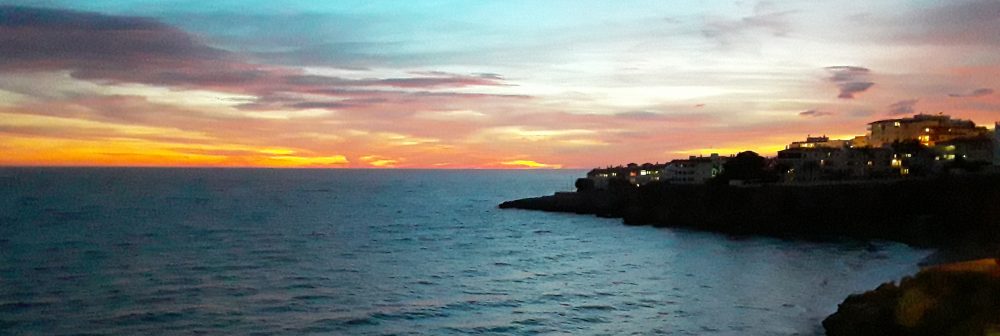
One morning we woke up in Utah, later that same day we were in Las Vegas, and that afternoon, between flights, we hopped a bus to the beach in Los Angeles and watched the sun set. Hours later, thanks to the wonders of technology, we arrived in Lima and soon thereafter set down in Cusco, former capital of the Incan empire and current center of Peru’s booming tourist scene. The city sits at 11,150’ above sea level, and we spent most of that afternoon huffing and puffing at elevation as we walked around town searching out supplies for the backpacking trip. Success came in the form of a 1:160,000 trekking map and several bottles of stove fuel. Groceries were purchased the following morning at the bustling central market, lunch eaten at a local restaurant, and a ride share located to take us out of Cusco. A couple hours later we were standing in the central square of Ollantaytambo, looking for the trail leading out of town, across the Rio Urubamba, and into the mountains.
Our packs were ridiculously heavy, bulging in all directions. Having no specific schedule, and not desiring one, we carried enough food to last us for at least 10 days without a resupply. The first leg of the hike also led up the side of a mountain, with no promise of a water source until late on day two, which meant we also had to carry several gallons of water between us. Loaded down, yet anxious to get away from town that afternoon, we headed out of Ollantaytambo around four and walked uphill for several miles before finding an acceptable place to camp around dusk. Once we got the tent set up, I moved behind it just in time to miss a good trampling by a charging cow. She was being pursued by an older gentleman, outfitted in a sweater vest and worn dress shoes, swiftly chasing her down the hill, a handful of throwing rocks at the ready. An unexpected show so late in the day.
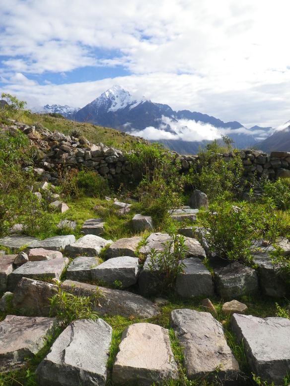
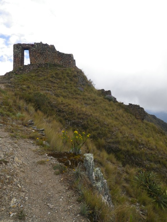
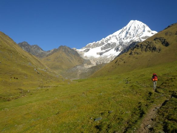
As close as we were to the equator, dark came on early. A cold stiff wind welcomed us to the Andes, along with a sky full of not-quite-familiar stars above and the lightscape of town in the valley below. Almost 12 hours of night allowed for plenty of needed rest after days of travel. Recharged, we were up at first light the next morning, packs on, gaining elevation with every step. After an hour or so of hiking, we arrived at a site called Las Canterras, an ancient Incan rock quarry which once processed stones for the massive Ollantaytambo complexes in the valley. We explored for a while, and enjoyed our morning coffee and breakfast in the sun along with the stunning views from the site. Impossible to imagine how they transported the rocks from that location to mountainside sites barely visible across the imposing valley. From there it was up some more, where we eventually arrived at another ruin site called Inti Punku. Several interpretations are offered for the original purpose of this outlook, now reduced to a substantial framed window and remnants of walls. Some say it was a lookout providing a vantage of several interconnecting valleys, while others believe it was a place of spiritual ritual where shamans convened with mountain spirits. All seemed plausible as shifting clouds parted, providing a view of two rivers below while the Veronica Glacier mystically appeared far above us.
Until now, the trail was entirely obvious, but from here things were to become a bit more convoluted, though we wouldn’t realize it for hours to come. This part of the route was key to the trip we had intended, but the trail was not represented on any map, and the only directions we had proved to be severely flawed. Or if they weren’t, the original path must be long grown over or completely nonexistent these days. The first part was easy enough, from Inti Punku we walked along an old Incan aqueduct for a while, then began descending into the next valley, down towards the Rio Silque. The trail dropped down a steep series of knee-buckling switchbacks before traversing along a shelf around a 1000’ above the river. The views were unbelievable, our enthusiasm unbridled. After a couple of miles, we found an amazing lunch spot in the middle of it all, nonstop beauty in every direction. After lunch, we kept cruising, starting to search in earnest now for the trail that was supposed to lead down the rest of the way to the river. Instead, we began to climb again. And climb and climb. The trail was certainly not headed the way we wanted to go, quite the opposite in fact, as it rose back into the mountains, leading ever further away from the river valley. Water began to be a concern.

At this point Erin mentioned that she had seen a trail from the lunch spot, though neglected to mention it as it was a long ways off in the distance, much further even, turns out, than we had traveled since leaving Inti Punku. After some discussion, we decided we needed to backtrack looking for a way down, rather than going up any further. Reluctantly, we trudged back the opposite direction. Indeed, there appeared to be a trail visible miles away from the lunch spot, though while it seemed to drop into the valley from the other side of Inti Punku, it was not at all what had been described, and it was a disheartening distance in the opposite direction. Not at all what we were looking for, but having returned so far already, and having not seen even a remote possibility of a trail downwards, we decided to accept our fate, continuing our reversal back up those brutal switchbacks with our brutal packs on in hopes of following that distant trail down to the river. Along the way we bushwhacked down multiple game trails hoping to find anything to lead us to the Silque, but we were only torturing ourselves as they disappeared straight off the sides of the cliffs below us. In our desperation, however, we did discover a small spring which allowed us to refill our water and alleviate the one true danger of an otherwise merely infuriating experience.
Back at the base of Inti Punku again, things were more frustrating than ever. The trail that we had spotted from so far back turned out to have been an illusion created by sunshine, shadow, and terrain. There was no remote possibility of descending into the valley from that side, the only way to anywhere we needed to be being the direction we had just come from, or back into the valley we had hiked up in the morning. I was incredibly aggravated at this point, though unwilling to admit defeat and spend an extra day backtracking in order to go the long way around to the Silque. We were completely exhausted from a long day of both physical and emotional ups and downs, and grudgingly decided to set up camp in one of the most stunning places imaginable. Ice covered Mount Veronica glimmered brilliantly in the late afternoon sunshine, the deep black silhouette of Yana Orqo sat to our west, and Inti Punku was a short walk away. It was impossible to stay irritated for long.
As we were setting up camp, a group of 25 or so people began filtering down towards the site from up on the mountain behind us. It was a trekking group on their third day of walking, and they were headed to Ollantaytambo. That night, they were going down about a half-mile or so to where mule packers, having arrived with their loaded pack train earlier in the day, had their camp set up and dinner waiting. Later in the trip, we would see more and more groups like this. In fact, almost everyone else we saw on the trails we would eventually hike, which was almost no one for many days, then lots of people on the last couple of days, was part of a trekking tour. First the horses and mules, then, large groups of hikers with small day packs and a guide or two. I took the opportunity to speak to the lead guide about the trail we were looking for; he said that no such trail existed, which made me feel both somewhat better and more irritated at the same time. I mean, it was in a book! We had the book… He explained that the trail we had been on probably went up into the mountains, and that it might eventually lead to the headwaters, but suggested that we go back down the mountain and over to the mouth of the Silque, and back up from there. Exactly what we were dreading, but an option we had to consider all the same.
An hour or so later, the sky lit up orange around us as the sun began to slowly fade into the mountains. Shadows set across the valleys below. I walked along the ridge towards Inti Punku, the stone structure radiant in the gloaming as it caught the last direct rays of sun. Another younger guide from the trekking group had run back up the steep hill from camp to photograph the event, only to have the battery on his camera die a few shots into his efforts. He and I stood just below the ruins, chilled by the evening winds, but faces still warm from the soft light of sunset, and chatted until it was time for him to head back down. Very congenial, in the course of ten minutes or so, he told me many stories about the Inca, about their beliefs and customs and respect for nature, about the Wacay Wilka, or the spirits that live in sacred natural formations, and about mountain biking and the ‘Inka Avalanche,’ an annual race down Abra Malaga, a steep pass coming down the other side of the valley – which he had both scars and tales of glory from. We also discussed options for my own plans, and while he doubted there was a trail down to the river, he believed we could go up and around, coming off the mountain near the confluence we were looking for. Exactly what I wanted to hear.

After another long night of sleep, we were up at dawn again packing up and discussing our options. I really did not want to turn around and go all the way back down to Ollantaytambo and simply give up on the original route. To admit defeat. Quit. What have you. As such, we agreed that we would simply follow the trail we were on the day before and see where it led, and eventually find a way down off the mountain. And if we didn’t? We would just hang out for a day or two and see what was out there and walk back the way we came from. There would be no real pressure to get anywhere, as we had enough food for days and days of travel, and all of our gear, and no final destination set anyways. After all, the original intention of the trip was just to be somewhere, rather than to go somewhere. So that’s what we did, third times a charmed it, and, like always, it all worked out in the end.
It was back along the old Incan sidewalk, back down those damned switchbacks, back to the little spring we’d found the day before, spotting a few deer on the way, and back to our original lunch spot, only this time for coffee and oatmeal in the warming rays of the rising sun. From there it was over to and back up the other switchbacks, and finally on to new sights and fresh territory. And up and up we went, up the mountain indeed. The one gut sinking doubt of the day came when we knew we were almost to the top of the canyon, knew it as we followed small brook up and along paradisiacal meadows, only to arrive at the base of a sheer cliff where both water and trail seemed to completely disappear. We looked at each other in downtrodden disbelief at the thought of such rude defeat. In fact, we kind of just sat there feeling sorry for ourselves for a quick moment until we finally saw it, saw the crack in the rock and the creek pouring though it and upon closer inspection realized that we didn’t even have to get wet as we walked up into the cliff and through that bit of mountain and eventually out the other side of it into a pastoral wonderland of a mountain valley replete with streams, flowing grasses, rolling hills, and sunshine in abundance.
And there, the trail, solid and obvious as it had been all morning, really did disappear. Or rather, it morphed into dozens of faint stock paths going in no particular direction. We continued to walk up towards the hills a ways, past a few horses, and finally to within view of a large rustic ranch tucked away in an astounding bucolic setting hours and hours of travel from the nearest road. There was a large flock of sheep, several horses, maybe a cow or two, and an enormous circular lodge with thatched roof. All of it in the middle of nowhere, as they say, but obviously the center of everywhere for the people that live there. To see something like this is to travel back at least two centuries through time. The faint silhouette of a human figure walked out of the house towards the sheep, studying us from afar for a brief second before heading on to the business at hand. We were the world encroaching, a not uncommon site these days, I’m sure. Best to pretend it doesn’t exist for at least a little while longer.
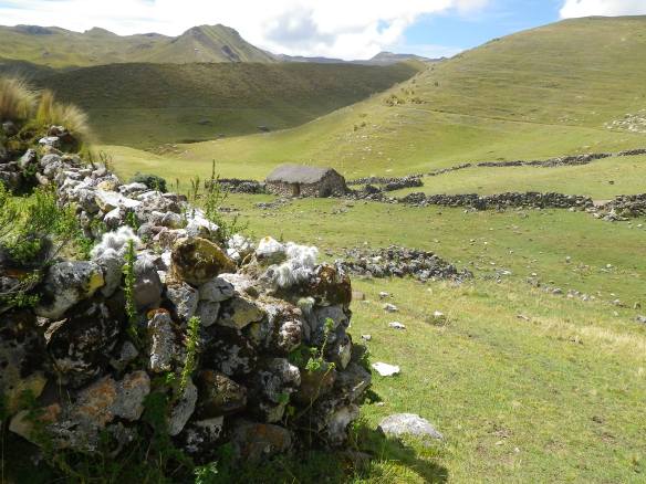
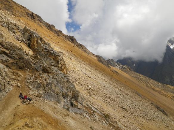
From there, we picked the most obvious path heading back towards the canyon rim and started to go in that general direction, weaving from one trail to the next as we climbed and traversed the steep hillsides. Across the next hill we came upon a vacant ranch with enormous livestock pens and dwellings built out of stacked stones. We would see many similar constructions in the days to come, structures that must have taken weeks of hard labor to complete, most of them seemingly abandoned. We continued to go up, trying to stay as close to the valley as possible, but fearing to walk too far in the direction of the sheer drop-offs along the edge. Before too long we were walking on skinny trails on the sides of impossibly steep hills, with potentially nasty consequences in the event of a misstep. We traversed like this for a couple of hours, the drops to the right of us growing in magnitude all the while. The scenery was incredible, the sense of isolation almost overwhelming. It was a lot to handle, in a good way. Time slowed way down for a while.
Around lunch time the exposure was beginning to wear on Erin. It was time to either go down, go back, or at least get away from the edge. We found a spot to hang out for a while, with impressive views of the mountains across from us, the river valley, and a glimpse of the confluence we needed to descend to, at least a thousand feet below us. While Erin made lunch, I went to do a quick scout, and eventually found what looked like a potential way down. It was impossible to tell if it went all the way, somehow threading between the ubiquitous precipices, however, or if it terminated at the top of a cliff. No matter what, it was the only remotely promising option we’d seen, and after a rest and a bite to eat we headed down. Steep steep, slightly scary, and questionable for quite a while, it went.
The bottom of the trail we eventually ended up on led to the base of a travertine falls where we rested for a while. From there, we walked through the scattered community of Silque, or Sallyapampa, or Ancashcocha depending on the source of information, and found a small bridge across the river. (Quick note here, to my understanding, there is no standardized spelling of the Quechua language, and names for everything from rivers to mountains to towns, both in spelling and as titular designations, vary greatly from source to source). And then we started to climb once more. For the rest of the afternoon we walked alongside a clear glacial stream. There were big views of Mt. Huayanay to the north, waterfalls cascading from its crevassed slopes into the open valley below. It appeared as if several families lived throughout the valley, with traditional homes dotted along the way, along with sheep, pigs, cows, and the only herd of alpaca we saw along the entire route.

It was a big climb, and we started to tire at the end, though wanted to try to make it up to Corrie Lake at the base of Abra Huayanay, the first major pass of our trip. As we neared the lake, we noticed a local family coming down from the pass, herding several horses in front of them. One of the men waved and shouted to us, asking if we spoke Spanish, and then came running down the steep slope with his small son on his shoulders to greet us. An impressive display of nonchalant athleticism. We had a nice conversation and he mostly just wanted to provide us with positive information about the pass and about where to camp before running on to catch up with the rest of his group. A little while later we were setting the tent up overlooking the lake. It was getting dark, and cold, and we made dinner and got into our sleeping bags for the night.
The next morning everything went south. I don’t want to dwell on the details, but the short of it is that we got sick. Very sick. And it would be a long time before we were completely back to normal, not until days after the trip, in fact. Our first assessment was acute mountain sickness, as we had ALL of the symptoms ever listed for altitude induced illness: nausea, vomiting, extreme fatigue, headache, diarrhea… It seemed to fit as we were at just under 14,000 ft. and had rigorously exerted ourselves from the time we arrived in Peru three days prior. But soon enough we began to suspect that altitude only played a small part in what was happening. In the end, it was obviously a lot more than that. Giardia, salmonella, dysentery… Something of the sort, most likely giardia, caused, not by drinking contaminated water in the backcountry, but inattention in the city the short time we were there. After years of traveling in Latin America, where not even in the scruffiest dirt floor restaurant in rural Mexico would anyone think to serve you a drink made with unpurified water, it only occurred to us in hindsight that perhaps more caution should have been taken in Peru. In discussing it afterwards, we’d actually both experienced unvoiced uncertainty at least a couple of times in Cusco. We probably could’ve been contaminated in six different places, at least, but no matter in the end. That was simply our reality for days to come. I would be lying if I said it didn’t overshadow the rest of the trip, but we did our best to not let it completely engulf the experience.
That first day it hit was horrible, however. I have been all kinds of sick in many a wilderness setting, but never have I known misery in the mountains like that morning. Foregoing any sort of breakfast we slowly started up the pass, the top of which sits at around 15,125’. From where we camped, it was only a few miles to the top, though with a gain of about 500’ each mile. On a normal day, it would’ve taken us around an hour to get there. But we fought for every labored movement, stringing out five or six steps in a row, at best, then leaning forward onto the one pole we each carried while struggling for minutes to breathe and stay upright. Erin, who is almost never ill, was taking it particularly hard. Early on, she laid down on the trail with her pack still attached. Angry at the dramatization, I yelled at her to get up and stop feeling sorry for herself. I think my own illness was a bit delayed from hers, as she had started throwing up the night before; less than 15 minutes later I was seriously considering crashing to the ground myself, honestly feeling incapable of taking another step. It was several hours before we finally reached the top of the pass, and the first time I’ve ever bothered to place a rock on a cairn pile in thanksgiving.
It was chilly on the pass, and we were both eager to drop down in elevation. We did not tarry long to enjoy the scenery. Survival mode. The trail on the other side led quickly down the mountain into a steep narrow valley. Once we were down a ways, ensconced near a small brook and out of the wind, I did indeed sit down, refusing to move until I’d properly rested for a while. I slept in the sunshine for an hour or so while Erin made herself some breakfast. Afterward, we mustered up the energy to continue on for several miles before setting up the tent in the early afternoon and sleeping feverishly for hours on end. We wouldn’t move again until late the next morning. The trail down followed a dramatic gorge, mountains rising straight up on either side. Cascades in abundance. We were on the edge again, and in the middle of some fantastic country. The campsite itself was tucked away in a small canyon right next to the river, hanging glacier on one side, abrupt valley on the other, an idyllic setting if ever there was one. At least there was that.

The next morning showed faint hope of recuperation. We moved slowly through our tasks, cooking, eating, packing. Severely downtrodden, we discussed potential alternatives to continuing on, even though we felt as if we’d only gotten started. There was an option later that afternoon to continue heading down and back to the highway, if we truly needed it. The original plan called for dropping another couple thousand feet to a confluence, then taking a left and walking straight back up even higher, crossing the toughest pass of the trip the very next day. We tried to leave our decision open until later in the day, but we both knew that there was no way we could repeat the previous day’s events on the same scale, much less an even more demanding one.
Down we went. A beautiful trail. A beautiful day. High alpine turned to jungle. Thick vegetation and instant humidity. The river continued to cascade below, offering us occasional glimpses as it fell and fell and fell. We walked past ruins and through small Quechuan communities. We started to feel just a little bit better, again leading us to erroneously wonder if it wasn’t the altitude after all. Around lunch time we arrived at the confluence, also the site of the impressive Paucarcancha ruins only a few miles from the beginning of the most famous Inca Trail (reality being that all of the trails in the Sacred Valley were regularly traveled by the Inca (yet another misnomer as only the royalty were actually ‘Inca’, but I digress)) – which terminates at Machu Picchu. Dropping our packs for a while, we walked slowly around the grounds inside the fortified stone walls. After a barefoot lunch in the sun overlooking the compound, it was time to make a decision.
If you know either one of us, you probably know which way we went. Feeling marginally better, and kind of preferring straight dying to giving up, we put our packs back on and headed up the next hill. We’ll just see how it goes, we told ourselves, we can always turn around… Miles later we were still going up. No real middle ground, no cruisy walking level ground, to be found on this trip. It was along another river, the Rio Cusichaca, which we climbed. Along the way we met a local man who was eager to talk to us, though we had to wait until we caught up with his friend, who knew a little Spanish, for the conversation. Many of the inhabitants of this region speak only their native Quechua, using Spanish as a distant second language, if at all. We chatted for a while, mostly about where we were going, as they seemed enthused to ply us with information about the area. What they were most interested in, however, was if we had any coca leaves, which the people there habitually chew on without rest. We did, indeed, have a small bag of dried leaves for making tea, said to act as a prophylactic against altitude illness, and shook out a couple of sparing piles into their eagerly extended hands. At this, they stuffed the handfuls into their mouths said goodbye, both quickly mounting small mountain ponies and heading up a side path towards their homes.
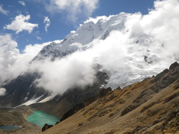
That evening we made camp in the small community of Pampacahuana, a few houses scattered across a broad flat valley where the suddenly level river, perhaps due to an optical illusion of watching it fall at speed for so many miles, seemed to be flowing uphill through still intact Incan aqueducts. We were out of the tent at dawn the next day and soon on our way up the long trail to the 16,000’ high pass of Abra Inkachiriasca. One of the good things about not doing a lot of research before a trip is not having any real expectations, so when the gargantuan snow covered peak of Mount Salkantay came into view all at once and without warning as we rounded a bend in the trail that morning, it was a moment of genuine fascination. Feeling decent, and wanting to ride that energy while we had it, we climbed for an hour or so before pausing for breakfast at the base of impressive Salkantay. One of my favorite parts of the trip was that morning and sitting between braided glacial streams sipping on coffee and staring awestruck at the mountain, dazzling in the early sunshine.
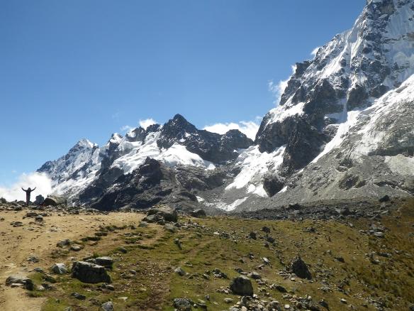
After fueling up, we put the packs back on and walked slow and steady for several hours. Up and up, but feeling kind of normal tired rather than extreme fatigued. Walking over the pass itself, no more than a quick step across a knife ridge, was also an incredible highlight. The mountain even closer than ever, the first view of the open landscape on the other side featured a brilliant turquoise lake at its base. Clouds floated well below us, as snow covered slopes extended thousands of feet above. We spent a long time up there, just hanging out and trying to take it all in.
We walked down the other side for several miles before making camp next to a series of waterfalls cascading down the edge of a colossal lateral moraine. In this tight valley, the sun started to go down early and the wind picked up quick. Luckily, we had a small cave to hang out in for a while and make dinner. Lying in the tent soon afterwards, an impressive storm rolled through, coating everything around with a thick layer of hail and shaking the ground with rolling trains of thunder.
The following day the plan was to join up with the Salkantay route, which is the most popular trek in Peru these days, being that, unlike the classic Inca Trail, it’s still unpermitted, unregulated, and ends up in the vicinity of Machu Picchu, with options to hike in to Aguas Calientes, the terminus of the train line and gateway to the ruins. As we hung out in camp that morning waiting for the sun, we had an excellent vantage point from which to look down a few hundred feet to the trail junction below, allowing us to see what we were in for. Up until this point, we’d only seen the one group of hikers near Inti Punku and a couple of smaller groups heading down the opposite side of the pass the day before. Otherwise, we’d been walking completely alone with a welcome sense of almost complete isolation. We’d had these remarkable valleys and extraordinary mountains and serene campsites and miles and miles of trail all to ourselves. That morning we saw crowds of people walking up the valley, along with string after string of loaded mules and packers. It was quite the sight, as each time we looked back down, more and more traffic filtered past. I’d read that it was a heavily traveled trail, but nothing had prepared me for those numbers.
The night before had been a bit of a relapse as far as the ailment was concerned, so we took it easy that morning, enjoying breakfast in camp and casually packing up. We had one more 15,000’ pass to climb, Abra Salkantay, and after that it would be down down down. It took me a while to build up my enthusiasm after an agitated night and then seeing all those people, but eventually I summed up the requisite motivation to move. Slowly. We dropped down into the valley below, crossed the foot of the moraine, and merged onto the 20’ wide scar of dirt and horse shit that was the Salkantay route. Fortunately, the late start worked in our advantage, and we found our own little hiking space for most of the morning. Yet, while there weren’t many hikers around, we were regularly passed by pack trains headed in both directions. By the end of the day, we estimated that we had probably seen over 500 horses and mules, and the relentless smell of ammonia and dung was nauseating. The Stinka Trail.
Throughout all of the areas we traveled through, there was widespread evidence of the heavy impact of livestock. It was impossible to set down pack or tent in any space free of horse or cow manure, and even the steepest of mountainsides were striated with crosshatched stock trails. Free roaming hogs caused wholesale devastation by snouting up large swaths of land. But this was on another level. As mentioned, unregulated. Turns out almost everyone hiking the trail that day started in the nearby village of Salkantaypampa, arriving by van early in the a.m. Most of them were in groups of around 25 people and had signed up with one of the myriad tour companies prevalent all over Peru. And there were dozens of these groups, that day and every day of the year, apparently. Literally hundreds of people. The pack trains carry their gear up the pass and either on to a backcountry campsite, or all the way over to the party/camping village of Chaullay, around 13 miles away. The next morning some of the groups continue hiking for another day down to Playa Sawayaco, others walk the road for a ways before getting picked up, and still others get trucked straight out of town while the mules and packers head back for the next load. An unfettered system, or lack thereof, which demonstrates complete lack of concern for quality of experience or preservation of resources.
But, if you can handle the stench, and ignore the environmental degradation, it’s still a great stretch of trail. Spectacular, in fact, as far as scenery is concerned. Around the time we reached the top of the pass, a thick bank of clouds began to rise up the valley. After a quick look around, we began our long descent. Happy to be losing elevation, we increased our tempo and maintained a hasty pace for the rest of the day. Down we went, down through a valley marked by enormous steppes and scattered boulders of colossal size. An hour or so after the pass we caught up with the first of the groups, and from then on we were in the mix. Before long we were out of the fog, and into the jungle. The plants got instantly bigger and greener. The trail dropped and dropped as did the Rio Wamantay down below it. Just when we thought we were going to meet up with the water, the river would disappear again, nowhere to be seen in the gorge below.
Late in the afternoon we arrived, shocked, in the village of Chaullay, a tightly condensed collection of campgrounds, cabins, and bars where almost all of the groups were heading for the night. There were cars, and crowds, and noise. People everywhere, and a couple hundred more coming down on the trail behind us. After so many days of solitude, it was simply too much.
We ended up fleeing for another mile down the road to the neighboring village of Colcapampa, also full of campgrounds, all of them empty. We set our tent up in the last one, and slept well. The next day we were back on the trail early, as were several of the groups, but there were significantly less people, many of them having already moved on to other activities, and no mules at all. And there were wild strawberries everywhere. Yes. This part of the trail traversed along the Rio Totora, another chaotic waterway frothing violently down the mountain. Up and down, up and down, went the trail, but never quite all the way down to the river, which was so what I wanted to happen so that we could just sit on a riverbank for a while and do nothing but rest and listen to the rapids and soak in the sunshine and pretend not to be plagued by gastrointestinal illness. Eventually, just as the day was really starting to heat up, a side trail took us down to a bridge and all my dreams came true for a few hours. We rinsed off in frigid mountain water and baked in the jungle sun and napped in the river sand and the remaining groups walked right on past us and by the time we got going again we never saw another person. Brilliant.
By this time, eight days into it or so, and still suffering from waves of sickness, we were thinking about being done. We’d seen a lot of incredible country, passed through some remote areas of rural Peru, crossed a few passes, and walked a good distance with some ridiculously heavy packs (we were still carrying about ten extra pounds of food apiece!). While there were options to keep going for a couple more days, we were content with all we’d seen, and also ready to get some rest and maybe some drugs for whatever else we were towing around. Before shouldering our packs once more and leaving the beach, we made the decision to camp out one more night, and head into town the next day.
The trail continued to follow the turbulent river for several miles, eventually leading us into the small town of Playa Sawayaco, where we spent the night in the backyard of a friendly local family. In the morning, we piled our gear into the back of a hatchback and shared a ‘collectivo’ ride down the bumpy dirt road to the town of Santa Teresa. The woman in the backseat with us was a real ‘chismosa’ who cracked me up with her steam-of-consciousness gossip about everyone in town. Every now and again it would get quiet for a bit and I’d look over to see her dozing away. She’d wake up soon enough, however, and start up again right where she’d let off. The driver, a too cool ‘papi-chulo’ type, gave her just the right amount of encouragement to keep it going all the way to the town square.
The town of Santa Elena was surprisingly quaint. A beautiful central plaza, and several clean streets lined with small restaurants and businesses. The driver dropped us at his friend’s hotel, and we spent a couple of hours organizing our lives and shifting focus. The itinerary for the rest of the day entailed checking out the Cocalmayo hot springs, right outside of town, and not much else. We took a moto-taxi out to the site, and spent hours relaxing in the thermal pools and sleeping in the sun. Back in town that evening we found a place for happy hour and ended up stuffing ourselves on various local appetizers, which seemed like a good idea in the moment, but quickly went the other direction, prompting us to cease the denial once and for all. Over to the pharmacist we went, and after listening to our symptoms, he knowingly confirmed our diagnosis of giardia before giving us a thorough briefing on the course of action and medicines recommended. We readily accepted his advice, purchased and instantly digested the first of the pills, and felt substantially better less than an hour later, though it was still a slow road to full recovery.
The next day we found another collectivo headed out of town, and enjoyed the scenic mountain drive over to Santa Maria. Here we spent a couple of hours waiting for our next ride, the long chug up 14,000’ Abra Malaga and the terrifying plunge down into Ollantaytambo. Thankful to have survived the bus ride once we finally arrived, we found a room for the night, and walked up to some impressive ruins on the hill above town. Having only a couple of days left in the country, it was now time to start sampling as much local fare as possible, starting with one of the best cocktails I have ever enjoyed, a Chicha Sour, variant of the famed Pisco Sour, though the pisco itself is imbued with purple corn along with other ingredients such as cinnamon and cloves. Wow. This started a nightly trend of sampling other sours, such as the traditional and the Coca Sour, all different but equally delicious. We also discovered Chicha Morada, a non-alcoholic beverage made of the purple corn, served at almost all restaurants, and I couldn’t drink enough of it those last couple of days.


From that point on, as we recovered from days of dehydration and inadequate nutrition, we couldn’t stop eating. It was actually kind of fun. The next morning we had breakfast at a coffee shop, then walked a few blocks across town to an empanada place where we proceeded to put down an even bigger meal than the first. Afterwards, wanting to spend a bit of time with a local guide, we walked one door over to a tour company and headed out for a half-day of mountain biking. It was a good time, and our guide, Abel, proved to be a wealth of information, answering all of the questions I’d come up with while in Peru. We did some fun riding, stopped for a while in the town of Maras, and then visited the Salineras de Maras, a unique salt production zone which predates the Incan empire. The mine itself continues to be operated by local families, and provides significant revenue from the production and sale of salt, and even more significantly, through tourism. The site consists of numerous terraced shelves of small pools, each of which is filled by a network of intricate irrigation tubes stemming from a salinized spring at the top of the hill. From there, it was a section of brake testing single-track back down the Rio Urubamba.


That evening we were back in Cusco, strolling through the streets and plazas. In the morning we looked up a ‘Free Walking Tour,’ something we discovered while in Buenos Aires a couple years back. The tours, actually ‘tip based,’ can be found in cities around the world, and are conducted by knowledgeable local guides well versed on all sorts of local history. There were numerous options available that morning, as it’s an easy way for residents to make some quick cash, and we considered ourselves lucky to join up with Sergio, who really seemed to enjoy relating elaborate stories pertaining to Cusco throughout the various centuries of its existence. In the afternoon and evening, we ate. And looked around a little, and ate some more, drank some chicha morada etc. We went to a couple of Incan sites in town, and marveled at their sophisticated stone work, still prominent along the narrow streets. We also had a fun conversation with an indigenous artist selling small gourds covered in intricately carved scenes of Peru’s history.


The next morning we were up early and out the door. A few movie binging plane flights later, we were thousands of miles away, the Andes replaced by Alaskan ranges and different ventures, but recollections of Abra Inkachiriasca and the sides of Mt. Salkantay seared in our minds. Dreams of Chicha Sours beckoning eventual return.

This post, along with others you have posted, leaves me longing to be there…minus the ailments. At least I can make the journey through your writings. Thanks for that! DV
LikeLike